|
Haiti could be spared hurricane threat from BERTHA, next 24 hours critical Aug 1, 2014 |
News
HaitiAction.net
|
||||
 |
 |
 |
 |
 |
 |
 |
| Tropical Storm BERTHA - 1 Aug 2014 1200Z - Location: 13.6 -58.0 - Winds: 55 knots - Central Pressure: 982mb Image courtesy of US Naval Research Lab |
Haiti could be spared hurricane threat from BERTHA, next 24 hours critical
Story Updated: Aug 1 - 1700Z
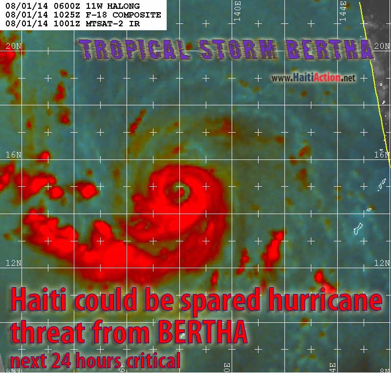
HaitiAction.net - Port au Prince, Haiti — Sometimes a tropical cyclone defies science and just seems to have a mind of it’s own. Tropical Storm BERTHA proved that overnight and simply motored through the expectations of the National Hurricane Center (NHC) in Miami; that it would simply dissipate in the presence of several conditions that are normally hostile to tropical cyclone formation. Without that adverse environment, it is likely, that BERTHA would have been a Category 3 Hurricane by now.
Sometimes it’s just easier to report exactly what you are seeing than trying to describe what you should be seeing.
The NHC has just released a report — #3 — that states: “Bertha is disorganized this morning. While satellite imagery shows a well-defined low-cloud swirl exposed just west of the main convective mass…” They do acknowledge that the satellite imagery is showing something completely contrary to their unique analysis of the collected data, yet, they are still stating that the cyclone is “disorganized.”
The satellite image above taken about the same time certainly does not look like Tropical Storm BERTHA is “disorganized,” to the contrary, it also shows that they should probably sharpen their pencils and be calling this a Category ONE hurricane instead, despite whatever data they have collected. That big hurricane-eye in the center of BERTHA looks fairly well organized…
I can’t resist drawing similar parallels to the US State Department’s supplied narrative that Fanmi Lavalas is “disorganized.”
 |
| click image above for full size ATCF track |
Back to the weather… Ahem.
First of all let me adjust my own forecast on Wednesday — that there was a likelihood that BERTHA could hit Au Cay by Monday/Tuesday. Today I’m pretty much in agreement with the consensus forecast track that has BERTHA curving to the north away from Haiti into a deep-layer trough expected to form over the next 72 hours, just east of Florida. The caveat is that what happens over the next 24 hours is critical and could just change everything. Dramatically.
Like I said, sometimes the storm will seem to have a mind of its own and just wander into more favorable conditions. If BERTHA misses Puerto Rico to the north, then (90%) Haiti should be in the clear. However, if BERTHA just keeps its current heading — 295º — and hits Martinique directly by tonight then Haiti should issue a Hurricane Watch for the entire country right away.
Even though the satellite images showed otherwise, yesterday, the NHC went with the data collected by its Hurricane Hunter aircraft and pretty much stated that the system was dissipating, but could reform quickly.
This is what’s happening that says that BETHA should be an afterthought by now:
1. Dry Air: Tropical cyclones need moist conditions and that big dusty nosebleed of a dry air mass stretched over the Atlantic should have been sucked into the energy core of the system by now and simply choked it. But it hasn’t.
2. Favorable winds: While the steering current have kept the nascent BERTHA formation in the ITCZ the least favorable wind formation is wind-shear which will — most likely — tear apart that incipient storm. The wind shear pattern that BERTA is in the middl of, right now, seems to have little effect. So far.
3. Forward speed: Tropical cyclones like cruising. Forward speed of the cyclone, below 11 knots, are more favorable to development. Cyclones that exceed the speed limit, get busted and usually begin a weakening trend. BERTHA has actually picked up some forward speed — 15 to 17kt — overnight while it has strengthened in intensity.
4. Warm SST (Sea Surface Temperature): The region that BETHA has traveled should have been dangerously warm by now. Actually, it is quite a bit cooler than normal. On the other hand…
…if BERTHA doesn’t take the preferred northward route, and loses a 290º heading the water just west of the Windward Islands is “dangerously warm” and the Tropical Cyclone will definitely and defiantly become a “Hurricane BERTHA” quicker than you can spell “Q U I C K !”
So, the NHC is actually using a rationale and fairly good science, it’s just that the pictures are telling the rest of us another story, right now.
The best news is the forward speed and the historical data. BERTHA’s forward speed should help it to overcome the weakening Sub-Tropical Ridge to the north and answer the pull of that developing “deep-layer trough” and harmlessly spin north between the East Coast of the USA and Bermuda — as being forecast right now by most computer models. The official track has BERTHA scraping the Mossad Coast of the Dominican Republic, but if BERTHA takes a 300º+ track over the next 12 hours we are predicting that it will miss the island entirely.
BERTHA could still become “disorganized” but it will not be a result of US propaganda. The Smith-Mundt Act was of no help to democracy in Haiti.
Story Updated: Aug 1 - 1700Z
BERTHA becoming a bit more "disorganized" and moving 292º at 22kt this should weaken the storm system overnight. However the system is tracking a bit more to the left. The danger will be if the cyclone slows the speed down below 15kt. As always check the National Hurricane Center page for latest official alerts
----------
RAW
----------
BOOKMARK the Haiti Action.net Tropical Cyclone Page for latest updates during this hurricane season.
View the latest observations near BERTHA
HaitiAction.net will be tracking the progress of this storm. For the latest official updates, go to the Centre National de Météorologie (CNM) web page Many forecast and tracking resources can be found on the Tropical Cyclone page at HaitiAction.net
BOOKMARK Haiti Action.net Tropical Cyclone Page
For Hurricane Season resources and updates
Share this story with your networks
SEE ALSO
Contact: info@haitiaction.org
Haiti could see Hurricane BERTHA next week July 30
Prisoners of Sugar May 7
1,500 Cholera victims in Haiti file lawsuit against UN in New York today Mar 11
UN Peacekeeper Misconduct in Haiti: panel discussion this Wednesday in Washington, DC Feb 24
Lovinsky Pierre Antoine
We are not Ghosts and will not be silenced July 19 2007
In Haiti, thousands of Lavalas sing "Aristide or Death!" Jan 9
Is the US Embassy in Haiti behind the political tensions? Jan 5
Haiti: Where is the Money? - Researcher Version Jan 4 2012
La Gavage: Obama helps Republican militarists take control in Haiti
May 13 2011
Haiti's close call: Hurricane IRENE scrapes the Mossad Coast before heading north Aug 22 2011
Hurricane MARIA could threaten Haiti next week Sep 6 2011
Haiti could kill EMILY's strength, but many in camps will still have a sleepless night Aug 3 2011
Haiti: Alarming resurgence of cholera Jun 9 2011
The return of President Aristide to his home in Haiti Mar 20 2011
Haiti: MSF Nears 100,000 Cholera Patients Treated Jan 18 2011