|
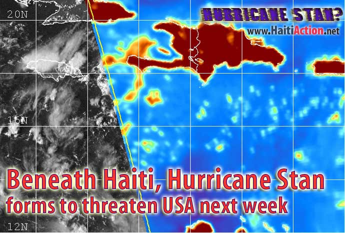
Beneath Haiti, Hurricane Stan forms to threaten USA next week
September 27, 2005
|
News
HaitiAction.net
|
||||
 |
 |
 |
 |
 |
 |
 |
|
|||||||
|
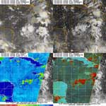
Tuesday, September 27, 2005 (Wednesday report below) Currently known as "99L Invest" a tropical depression was consolidating in the Caribbean directly south of Haiti last night and is now moving moving west-northwestward at approximately 10 mph. This slow progress will allow the system to gain strength over the warm waters of the Caribbean. The upper-level low on the western end of Cuba - that could have prevented the tropical cyclone from forming - has dissipated and now conditions are more favorable for "Tropical Storm Stan" to become the eighteenth named storm of the record 2005 hurricane season in the next couple of days. [Note: there are still two months left to this hurricane season that ends November 30, 2005] If that is the case, it's possible that the tropical storm could gain strength and become Hurricane Stan before moving into the Gulf. In the last couple of years extremely dangerous hurricanes - Hurricane Ivan and Hurricane Emily - have taken that similar route near the Yucatan Channel, which would threaten New Orleans with a storm surge for the third time this year. The National Hurricane Center of Miami Florida is warning interests in Jamaica, the Cayman Islands, Cuba and the rest of the northwest Caribbean to closely monitor the progress of this system over the next few days HaitiAction.net will have updates to this system as they affect this region. For the latest bulletins go to http://www.nhc.noaa.gov/ first. |
||||||||
|
|
||||||||
|
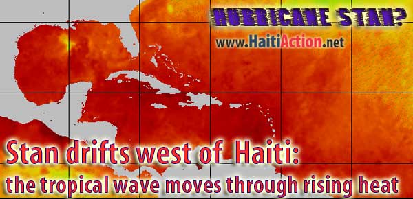
Officially known as "99L Invest" the weather system that will likely become the eighteenth named storm of the record 2005 hurricane season in the next couple of days as it ominously moves toward the battered Gulf States of the USA. As can be seen by the Composite Sea Surface Temperature — satellite image map above — the conditions are favorable for this system to gain strength as it moves through the Yucatan Channel into the Gulf of Mexico. The tropical wave could gain strength and become "Tropical Storm Stan" before moving into the Gulf. In the last couple of years extremely dangerous hurricanes - Hurricane Ivan and Hurricane Emily - have taken that similar route near the Yucatan Channel. After moving into The Gulf this system could find the warmest currents to become a hurricane which would threaten New Orleans with a storm surge for the third time this year. The National Hurricane Center of Miami Florida is warning interests in Jamaica, the Cayman Islands, Cuba and the rest of the northwest Caribbean to closely monitor the progress of this system over the next few days HaitiAction.net will have updates to this system as they affect this region. For the latest bulletins go to http://www.nhc.noaa.gov/ first. |
||||||||
|
Excerpts from most recent bulletins ABNT20 KNHC 280927 TWOAT TROPICAL WEATHER OUTLOOK 530 AM EDT WED SEP 28 2005 FOR THE NORTH ATLANTIC...CARIBBEAN SEA AND THE GULF OF MEXICO... SHOWER ACTIVITY WITH THE TROPICAL WAVE ENTERING THE WESTERN CARIBBEAN SEA IS CURRENTLY LIMITED AND DISORGANIZED. HOWEVER... UPPER-LEVEL WINDS ARE EXPECTED TO GRADUALLY BECOME MORE CONDUCIVE FOR DEVELOPMENT... AND THIS SYSTEM COULD BECOME A TROPICAL DEPRESSION DURING THE NEXT DAY OR TWO. AN AIR FORCE RESERVE UNIT RECONNAISSANCE AIRCRAFT IS SCHEDULED TO INVESTIGATE THIS SYSTEM LATER TODAY... IF NECESSARY. INTERESTS IN THE NORTHWESTERN CARIBBEAN SEA AND ADJACENT LAND AREAS SHOULD MONITOR THE PROGRESS OF THIS SYSTEM DURING THE NEXT FEW DAYS AS IT MOVES WEST-NORTHWESTWARD AT 10 TO 15 MPH. ELSEWHERE... TROPICAL STORM FORMATION IS NOT EXPECTED THROUGH THURSDAY. FORECASTER FRANKLIN .oOo.oOo.oOo.oOo.oOo.oOo.oOo.oOo.oOo.oOo.oOo.oOo.oOo.oOo.oOo.oOo.oOo. AXNT20 KNHC 281042 TWDAT TROPICAL WEATHER DISCUSSION NWS TPC/NATIONAL HURRICANE CENTER MIAMI FL 805 AM EDT WED SEP 28 2005 BASED ON 0600 UTC SURFACE ANALYSIS AND SATELLITE IMAGERY THROUGH 1015 UTC. ...SPECIAL FEATURE... CENTRAL CARIBBEAN TROPICAL WAVE IS ALONG 79W S OF 21N WITH A 1009 MB LOW ALONG THE WAVE NEAR 16N MOVING WNW NEAR 12 KT. LOW/MID LEVEL CIRCULATION IS NOT AS WELL DEFINED AS EARLIER AND AN UPPER LEVEL HIGH LOCATED E OF THE WAVE NEAR 19N74W. THIS AREA STILL HAS THE POTENTIAL OF BECOMING A TROPICAL CYCLONE WITHIN THE NEXT DAY OR TWO AS THE UPPER LEVEL WINDS BECOME MORE FAVORABLE. SCATTERED MODERATE/STRONG CONVECTION IS NEAR THE LOW FROM 13N-17N BETWEEN 78W-81W… $$ .oOo.oOo.oOo.oOo.oOo.oOo.oOo.oOo.oOo.oOo.oOo.oOo.oOo.oOo.oOo.oOo.oOo. AXNT20 KNHC 271706 TWDAT TROPICAL WEATHER DISCUSSION NWS TPC/NATIONAL HURRICANE CENTER MIAMI FL 205 PM EDT TUN SEP 27 2005 TROPICAL WEATHER DISCUSSION BASED ON 1200 UTC SURFACE ANALYSIS AND SATELLITE IMAGERY THROUGH 1645 UTC. ...SPECIAL FEATURE... CENTRAL CARIBBEAN TROPICAL WAVE IS ALONG 75W/76W S OF CUBA WITH A 1010 MB LOW ALONG THE WAVE NEAR 14N. OBSERVATIONS FROM BUOY 42058 SUGGEST THERE IS A WEAK LOW ASSOCIATED WITH THE WAVE WITH WLY WINDS RECENTLY REPORTED...THOUGH THOSE WINDS ARE LIKELY ENHANCED BY DOWNDRAFTS AND OUTFLOW BOUNDARIES. VISIBLE SATELLITE PICTURES SHOW BANDING FEATURES DEVELOPING ON THE N SIDE OF THE WAVE WITH SYMMETRIC OUTFLOW. THIS AREA HAS THE POTENTIAL TO BECOME A TROPICAL CYCLONE WITHIN THE NEXT 36 HOURS. A SLOW MOVEMENT TO THE WNW IS LIKELY... PLACING THE SYSTEM IN THE W CARIBBEAN LATE WED/EARLY THU. SCATTERED MODERATE CONVECTION IS FROM 13.5N-17.5N BETWEEN 74W-78W. HEAVY RAIN IS POSSIBLE FOR JAMAICA LATER TODAY AND OVERNIGHT. .oOo.oOo.oOo.oOo.oOo.oOo.oOo.oOo.oOo.oOo.oOo.oOo.oOo.oOo.oOo.oOo.oOo. ABNT20 KNHC 271502 TWOAT TROPICAL WEATHER OUTLOOK NWS TPC/NATIONAL HURRICANE CENTER MIAMI FL 1130 AM EDT TUE SEP 27 2005 FOR THE NORTH ATLANTIC...CARIBBEAN SEA AND THE GULF OF MEXICO... A VIGOROUS TROPICAL WAVE CENTERED A COUPLE HUNDRED MILES SOUTHEAST OF JAMAICA IS PRODUCING CLOUDINESS AND THUNDERSTORMS OVER MUCH OF THE CENTRAL CARIBBEAN SEA. THIS SYSTEM HAS BECOME BETTER ORGANIZED TODAY... AND UPPER-LEVEL WINDS HAVE ALSO BECOME MORE FAVORABLE FOR A TROPICAL DEPRESSION TO DEVELOP DURING THE NEXT DAY OR SO. AN AIR FORCE RESERVE UNIT RECONNAISSANCE AIRCRAFT IS SCHEDULED TO INVESTIGATE THE SYSTEM TOMORROW... IF NECESSARY. INTERESTS IN JAMAICA... THE CAYMAN ISLANDS... AND IN THE NORTHWESTERN CARIBBEAN SEA SHOULD CLOSELY MONITOR THE PROGRESS OF THIS SYSTEM OVER THE NEXT FEW DAYS AS IT MOVES WEST-NORTHWESTWARD AT ABOUT 10 MPH. .oOo.oOo.oOo.oOo.oOo.oOo.oOo.oOo.oOo.oOo.oOo.oOo.oOo.oOo.oOo.oOo.oOo. THE 1009 MB LOW NEAR 14N74W HAS DISSIPATED. WAVE IS BENEATH E TO SE UPPER FLOW AT THE BASE OF AN UPPER RIDGE TO THE E. SCATTERED STRONG CONVECTION IS WITHIN 60 NM OF 75.5W FROM 13N-16N AND SCATTERED MODERATE/ISOLATED STRONG CONVECTION IS WITHIN 45 NM OF 77W FROM 12N-17N. |