|
Haiti will see "Extremely Dangerous Hurricane DEAN" today
August 18, 2007 |
News
HaitiAction.net |
||||
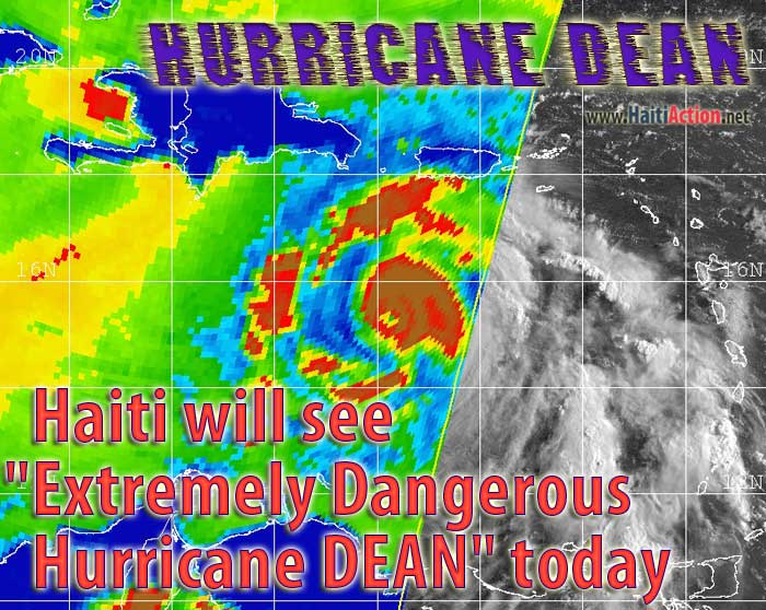 Haiti will see "Extremely Dangerous Hurricane DEAN" today
HaitiAction.net — Port au Prince, Haiti — "...DEAN'S FURY THREATENS HAITI...JAMAICA AND THE CAYMAN ISLANDS...HEAVY SQUALLS ALREADY APPROACHING HISPANIOLA... " claims the National Hurricane Center (NOAA) in Miami, Florida
The strongest Hurricane Haiti has ever seen could hit the island in the next 24 hours. The current projection is that the eye of the storm is forecast to pass 150 miles south of Port au Prince. Sustained hurricane force winds could be experienced over the entire southern coast of the island. A Tropical Storm Warning is in effect for all of the Dominican Republic and Haiti to the northern coast.
A Tropical Storm Warning means that tropical storm conditions are expected within the warning area within the next 24 hours. Currently the hurricane is staying within Category Four — Storm winds of 131-155 mph (114-135 kt or 210-249 km/hr) — "Dean could become a Category Five (+155 mph) at any time" according to NOAA forecasters. Hurricane force winds extend outward of the center (15.7 N - 68.6 W)up to 60 miles. Tropical Storm conditions extend outwards up to 205 miles.
Storm total rainfall amounts are predicted to be from 2 to 6 inches over the islands, certain to cause deadly mudslides and flach floods in some regions.
If this unpredictable hurricane veers north, like previous hurricanes in the past, there will need to be a massive regional response in the inevitable aftermath. Cuba could have enough considerable concerns of its own that it will not be able provide a medical response for Haiti. Venezuela could be in a position to offer the most emergency aid for Haiti.
The Preval government is implementing its own untested Hurricane Alert system throughout the country. Many poor populations live in hard to reach mountainous country that will experience flash floods. Most preparations need to be completed soon as the cyclone winds will make it impossible to fly even military helicopters over those areas.
FORECAST POSITIONS AND MAX WINDS
INITIAL 18/2100Z 16.1N 70.2W 130 KT
12HR VT 19/0600Z 16.8N 72.6W 135 KT
24HR VT 19/1800Z 17.7N 76.0W 135 KT
36HR VT 20/0600Z 18.5N 79.3W 125 KT
48HR VT 20/1800Z 19.5N 83.0W 140 KT
72HR VT 21/1800Z 21.5N 90.0W 100 KT
96HR VT 22/1800Z 23.0N 96.0W 105 KT
120HR VT 23/1800Z 24.5N 101.5W 40 KT...INLAND
Bookmark the Hurricane Dean Page on HaitiAction.net for satellite images, many links, resources and public advisories over the next few weeks.
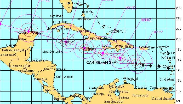
Above: Automated Tropical Cyclone Forecasting (ATCF) map from NRL Advisory 21 - August 18
ATCF Support Page
Bookmark the Hurricane Dean Page on HaitiAction.net for satellite images, many links, resources and public advisories over the next few weeks.