|
Haiti watches dangerous Hurricane Dean as Jamaica braces for direct hit
August 17, 2007 |
News
HaitiAction.net |
||||
 Haiti watches dangerous Hurricane Dean as Jamaica braces for direct hit
HaitiAction.net - Port au Prince, Haiti - Haiti could be spared the worst of "Dangerous Dean" the Category Four Hurricane racing through the Center of the Caribbean Sea. The steering currents revealed by the Mid-level Wind Shear Analysis - image above - by the National Weather Service (NOAA) could change the track of Hurricane Dean from 280 degrees (WbN) to a directly West heading of 270 degrees along Latidude 15N according to some weather analysts.
The consensus opinion is that Hurricane Dean will — most likely — hit Jamaica with Hurricane force winds by Sunday evening. The forward progress of Dean has slowed slightly allowing the warmer seas strengthen the tropical cyclone further. It is possible that Dean could reach Hurricane Category Five (155mph+) on the Safir-Simpson scale soon.
The local advisory for interests in the U.S. Virgin Islands and Puerto Rico reported earlier: " Tropical storm force winds have already been reported ... with the confIRMAtion of downed power lines and trees across southeastern Puerto Rico ... Tropical storm force winds extend outward up to 185 miles from the center."
Improved reporting from the area around Puerto Rico is due to the plan to place eight new hurricane buoys off Puerto Rico in an effort to fill a gap in important weather data coming from warm, storm-generating waters there. All eight buoys will be placed before the end of the hurricane season. Yesterday, the Preval government of Haiti launched the Alert Phase 1 in response to the threat of deadly floods wich are likely in the south. All coastal traffic operations are suspended on the entire south coastline from Friday 17 at night to Sunday night.
Heavy surf is predicted throughout the entire Caribbean with breaking waves reaching 10 to eighteen feet. Weather forecasters are also closely watching an ominous tropical depression forming in Hurricane Alley (7.3N 32.7W) that could form into another tropical cyclone to follow Hurricane Dean soon.
Air Jamaica, the national airline, said it would allow passengers scheduled to travel to certain Caribbean destinations between August 17 and 24 to reschedule without being penalised. Passengers must, however, request a deferral from the airline before the original departure date, the airline said yesterday.
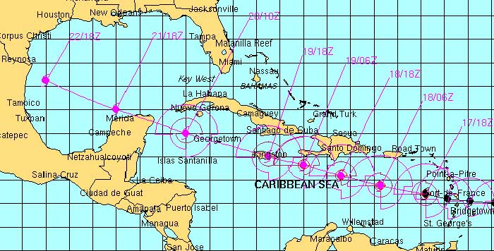
Even though it is possible that Hurricane Dean could pass Jamaica to the south. The consensus opinion shown by the NOAA forecast track - below - is that the dangerous hurricane straight to Jamaica stating "...the bottom line is that Dean is expected to be a DANGEROUS HURRICANE through the next several days and all interests in the Caribbean Sea and the Gulf of Mexico should closely monitor the progress of Dean."
Bookmark the Hurricane Dean Page on HaitiAction.net for satellite images, many links, resources and public advisories over the next few weeks.
Current shear charts for the ATLANTIC BASIN can be found at : http://cimss.ssec.wisc.edu/tropic/real-time/atlantic/winds/winds-shr.html
Bookmark the Hurricane Dean Page on HaitiAction.net for satellite images, many links, resources and public advisories over the next few weeks.