|
US Navy warns Haiti to prepare for Hurricane Emily
July 14, 2005
|
News
HaitiAction.net
|
||||
 |
 |
 |
 |
 |
 |
|
Check Hurricane Emily Page for the latest Satellite Images - Forecasts - News - Links |
|
|
Evidence mounts of |
|
| | |
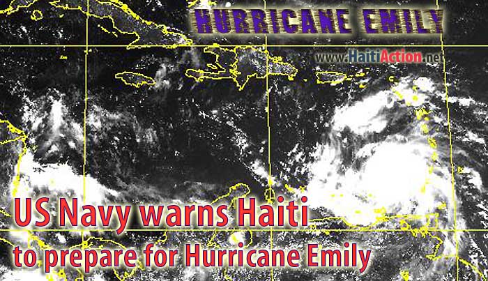
| Two images of the sixth storm — in Hurricane Alley — of the season 99L Invest
100L Invest — potentially — looks to be less than a week behind |
US Navy NMOC of Norfolk, Virginia Tropical Support page posted the above image from it's weather satellite. Together with "Strike Probability" guidance on the US Navy site, the Coup Government of Haiti has issued a Tropical Storm Watch" while the Category 2 hurricane approaches the island.
After brushing the northeast region of Venezuela, Hurricane Emily has veered north of it's westerly direction. While the steering currents could push it away from Haiti and the Dominican Republic, Jamaica's strike probability is a lot higher for the time being.
The tracking forecast maps have Emily brushing Jamaica before storming through the Yucatan Peninsula on its way to the Gulf of Mexico as it poses a significant threat to the State of Texas.
Meanwhile, in Port au Prince, this morning, the UN occupation force (MINUSTAH) reported that hunting down pro-democracy militants - what UN General Ribero prefers to call "bandits" - is a higher priority than preparing for the inevitable natural disaster caused by the hurricane season: "Both the Transitional Government and MINUSTAH are under heavy pressure for prompt visible actions to solve and control the security environment, especially in the key areas of the capital. "
The Haiti Emergency Situation Report (No. 39) also claimed that an assessment team consisting of WFP, UNICEF, UNDP, MINUSTAH, ACF and the Haitian Department of Civil Protection "over flew" the coastal areas to assess potential damages of Hurricane Dennis.
This is a record year for Hurricanes, already Hurricane Emily became the fifth named storm of the season which is 14 days sooner than the previous historical record. The Navy satellite images are tracking the next brewing storm "99L Invest" currently in Hurricane Alley and does have the potential to consolidate and become another big concern for the Caribbean next week.
Hurricane Emily has been an unusual formation and for a time being there was some hope that, it too, wouldn't be able to consolidate the rising air currents to become what it is now. The most recent images - just coming in of this writing - show a distinct eye and increasing organization of the menacing storm. If it slows its forward progress it could easily strengthen into a Category 3 hurricane by tonight.
Latest official forecast below:
WTNT25 KNHC 141431
TCMAT5
HURRICANE EMILY FORECAST/ADVISORY NUMBER 15
NWS TPC/NATIONAL HURRICANE CENTER MIAMI FL AL052005
1500Z THU JUL 14 2005
AT 11 AM AST...1500Z...THE GOVERNMENT OF THE DOMINICAN REPUBLIC HAS
ISSUED A TROPICAL STORM WATCH FROM PUNTA SALINAS WESTWARD TO THE
DOMINICAN REPUBLIC/HAITI BORDER. THE GOVERNMENT OF HAITI HAS
ISSUED A TROPICAL STORM WATCH FROM THE DOMINICAN REPUBLIC/HAITI
BORDER TO PORT-AU-PRINCE.
AT 11 AM AST...THE GOVERNMENT OF TRINIDAD HAS DISCONTINUED THE
TROPICAL STORM WARNING FOR GRENADA AND ITS DEPENDENCIES.
A TROPICAL STORM WARNING IS IN EFFECT FOR THE NORTHERN COAST OF
VENEZUELA FROM PEDERNALES WESTWARD TO PUNTO FIJO...INCLUDING ISLA
MARGARITA AND THE OFFSHORE ISLANDS NORTH OF THE COAST AND WEST OF
CUMANA.
A TROPICAL STORM WARNING IS IN EFFECT FOR BONAIRE...CURACAO...AND
ARUBA.
INTERESTS ELSEWHERE IN THE CENTRAL AND WESTERN CARIBBEAN SHOULD
MONITOR THE PROGRESS OF EMILY.
HURRICANE CENTER LOCATED NEAR 12.7N 64.0W AT 14/1500Z
POSITION ACCURATE WITHIN 20 NM
PRESENT MOVEMENT TOWARD THE WEST-NORTHWEST OR 285 DEGREES AT 16 KT
ESTIMATED MINIMUM CENTRAL PRESSURE 976 MB
EYE DIAMETER 10 NM
MAX SUSTAINED WINDS 85 KT WITH GUSTS TO 105 KT.
64 KT....... 30NE 20SE 0SW 20NW.
50 KT....... 60NE 40SE 20SW 50NW.
34 KT....... 90NE 90SE 40SW 90NW.
12 FT SEAS..175NE 90SE 60SW 125NW.
WINDS AND SEAS VARY GREATLY IN EACH QUADRANT. RADII IN NAUTICAL
MILES ARE THE LARGEST RADII EXPECTED ANYWHERE IN THAT QUADRANT.
REPEAT...CENTER LOCATED NEAR 12.7N 64.0W AT 14/1500Z
AT 14/1200Z CENTER WAS LOCATED NEAR 12.4N 63.2W
FORECAST VALID 15/0000Z 13.3N 66.4W
MAX WIND 90 KT...GUSTS 110 KT.
64 KT... 30NE 20SE 20SW 30NW.
50 KT... 60NE 50SE 30SW 60NW.
34 KT...100NE 90SE 75SW 100NW.
FORECAST VALID 15/1200Z 14.5N 69.9W
MAX WIND 100 KT...GUSTS 120 KT.
64 KT... 30NE 20SE 20SW 30NW.
50 KT... 75NE 60SE 60SW 75NW.
34 KT...120NE 90SE 90SW 120NW.
FORECAST VALID 16/0000Z 15.6N 73.3W
MAX WIND 105 KT...GUSTS 130 KT.
64 KT... 30NE 20SE 20SW 30NW.
50 KT... 75NE 60SE 60SW 75NW.
34 KT...120NE 90SE 90SW 120NW.
FORECAST VALID 16/1200Z 17.0N 76.8W
MAX WIND 110 KT...GUSTS 135 KT.
50 KT... 75NE 60SE 60SW 75NW.
34 KT...120NE 90SE 90SW 120NW.
FORECAST VALID 17/1200Z 19.0N 83.5W
MAX WIND 110 KT...GUSTS 135 KT.
50 KT... 75NE 60SE 60SW 75NW.
34 KT...120NE 90SE 90SW 120NW.
EXTENDED OUTLOOK. NOTE...ERRORS FOR TRACK HAVE AVERAGED NEAR 250 NM
ON DAY 4 AND 325 NM ON DAY 5...AND FOR INTENSITY NEAR 20 KT EACH DAY
OUTLOOK VALID 18/1200Z 21.0N 89.0W...INLAND
MAX WIND 90 KT...GUSTS 110 KT.
OUTLOOK VALID 19/1200Z 22.5N 94.0W
MAX WIND 100 KT...GUSTS 120 KT.
REQUEST FOR 3 HOURLY SHIP REPORTS WITHIN 300 MILES OF 12.7N 64.0W
NEXT ADVISORY AT 14/2100Z
FORECASTER FRANKLIN