|
HaitiAction.net Tropical Cyclone Page
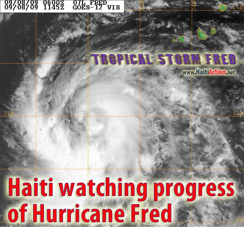 |
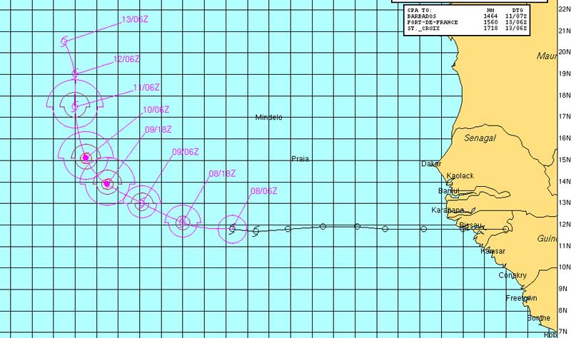
| The ominous shape of Tropical Storm Fred starts to show the development of an eye as it moves about 160 miles to the South of the Cape Verde Islands (colored green in upper right of this satellite image). Image courtesy of the US Navy. |
Haiti watching progress of Hurricane Fred
Haiti Action.net - Port au Prince, Haiti - Haiti is just recovering from deadly mudslides caused by the "remnants" of Tropical Storm ERIKA and will be watching the progress of a Cape Verde Hurricane as it crosses the Atlantic. According to the National Hurricane Center in Miami (NHC), Tropical Storm FRED could reach hurricane strength today. The current NHC forecast track is that FRED to curve northward and become an extratropical cyclone within 5 days, weakening as it heads into cooler waters and the "upper trough currently along 40W could start to induce southwesterly shear."
After a comparatively quiet start for the 2009 hurricane season for Haiti, the last few weeks have been active for tropical cyclone formation. Little official attention was paid to TS ERIKA as it weakened quickly after passing over the Leeward Islands becoming a tropical wave as it passed south of Puerto Rico. However, the storm dumped heavy rain for several hours over Haiti causing dangerous mudslides in several regions. So far, one death and four missing persons were reported to the Civil Protection Ministry in the seaside resort town of Mountrois — about 40 miles NNW of Port au Prince — destroying 34 houses as well.
The NHC expects FRED to reach hurricane category 2 strength before it weakens. "FRED is being steered primarily by by a mid-troposheric ridge to the north. This ridge should gradually diminish with time as a mid- to upper-level trough near 40W moves eastward." Some forecast models have FRED missing the first trough and maintaining a westerly heading directly towards the Caribbean region. If Hurricane FRED follows the same track as the previous Hurricane BILL it will come close to the Mid-Atlantic NOAA weather buoy and the NHC will likely have an entirely different forecast track. The next three days should see some significant shifting of the official forecast.
The last Cape Verde-type hurricane to reach Haiti was last year's devastating Hurricane IKE.
RAW
Bookmark this page for the 2009 Hurricane Season
2009 storm names:Ana, Bill, Claudette, Danny, Erika, Fred, Grace, Henri, Ida, Joaquin, Kate, Larry, Mindy, Nicholas, Odette, Peter, Rose, Sam, Teresa, Victor, Wanda |
View the latest NOAA observations
near Hurricane FRED
000
WTNT42 KNHC 101435
TCDAT2
HURRICANE FRED DISCUSSION NUMBER 12
NWS TPC/NATIONAL HURRICANE CENTER MIAMI FL AL072009
1100 AM AST THU SEP 10 2009
VISIBLE SATELLITE IMAGERY SHOWS THAT FRED STILL HAS AN EYE
SURROUNDED BY DEEP CONVECTION...ALTHOUGH IT IS NOT AS DISTINCT AS
IT WAS YESTERDAY. THE CLOUD PATTERN HAS BECOME A LITTLE BIT
ELONGATED DUE TO SOUTHERLY SHEAR THAT IS BEGINNING TO AFFECT THE
HURRICANE. T-NUMBERS HAVE COME DOWN AND SUPPORT AN INITIAL
INTENSITY OF 85 KNOTS. BECAUSE FRED IS HEADING TOWARD A HOSTILE
ENVIRONMENT OF STRONG SHEAR AND COOL WATERS...THE OFFICIAL FORECAST
CALLS FOR A GRADUAL WEAKENING. FRED COULD BECOME A REMNANT LOW BY
THE END OF THE FORECAST PERIOD OF EVEN EARLIER. THIS IS IN GOOD
AGREEMENT WITH THE SHIPS MODEL WHICH DISSIPATES THE CYCLONE AT 96
HOURS. BOTH THE GFDL AND HWRF MODELS MAINTAIN FRED AS STRONG
TROPICAL STORM OR HURRICANE BUT WITH SUCH PREVAILING HOSTILE
ENVIRONMENT...THIS IS NOT REALISTIC.
THE BEST ESTIMATE OF THE INITIAL MOTION IS 320 DEGREES AT 6 KNOTS.
HOWEVER...THE STEERING CURRENTS ARE FORECAST TO COLLAPSE AND FRED
IS EXPECTED TO SLOW DOWN AND DRIFT NORTHWARD OR MOST LIKELY IT WILL
MEANDER FOR TWO OR THREE DAYS. BY THEN...A RIDGE IS FORECAST TO
DEVELOP NORTH OF FRED...FORCING THE CYCLONE TO TAKE A MORE
WEST-NORTHWEST PATH AS INDICATED IN THE OFFICIAL FORECAST. MOST OF
THE TRACK GUIDANCE...PRIMARILY THE GLOBAL GFS AND THE ECMWF ARE
FORECASTING THE WESTWARD BEND. BY THEN...GIVEN THE PREVAILING
STRONG SHEAR FRED IS EXPECTED TO BE NO MORE THAN A WEAK DISTURBANCE
STEERED BY THE LOW-LEVEL FLOW.
FORECAST POSITIONS AND MAX WINDS
INITIAL 10/1500Z 16.8N 35.1W 85 KT
12HR VT 11/0000Z 17.5N 35.4W 75 KT
24HR VT 11/1200Z 18.0N 35.5W 65 KT
36HR VT 12/0000Z 18.2N 35.2W 55 KT
48HR VT 12/1200Z 18.6N 34.8W 45 KT
72HR VT 13/1200Z 20.5N 35.0W 35 KT
96HR VT 14/1200Z 22.0N 38.0W 30 KT
120HR VT 15/1200Z 24.0N 42.0W 25 KT...REMNANT LOW
$$
FORECASTER AVILA |