|
Tropical Storm DORIAN will threaten Haiti this Monday July 26, 2013
|
News
HaitiAction.net
|
||||
 |
 |
 |
 |
 |
 |
|
Tropical Storm DORIAN will threaten Haiti this Monday
UPDATED BELOW
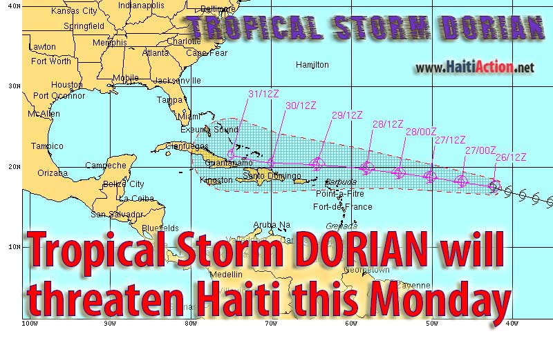
HaitiAction.net - Port au Prince, Haiti — A weakening Tropical Storm DORIAN — steady at 50 mph — is forecast to travel just north of Haiti next week. DORIAN is expected to strengthen slightly over the next few days, but some forecast models show that some dry air and significant wind shear could fully dissipate DORIAN into a tropical depression by the time it travels above Haiti.
Historically, tropical cyclones that travel north of PIRATA buoy 13008 Reggae will take a northerly track and spin towards Bermuda. However, an unusually strong deep-layer Subtropical Ridge is building in tandem with the westward motion of DORIAN and could keep it on a westerly track just north of Cuba into the Gulf.
DORIAN is not expected to directly impact Haiti longer than six hours but the northern regions could see an excess of 8 inches of rainfall in the mountains. The recent passing of the rainy season’s tropical waves have saturated the ground, so dangerous mudslides and flash floods are probable.
HaitiAction.net will follow the progress of this storm and the latest advisories can be found at Haiti’s Centre national de météorologie (CNM) and the USA’s National Hurricane Center (NHC).
Also the NHC has an interactive real-time Google map of DORIAN (ATL4)
BOOKMARK the Haiti Action.net Tropical Cyclone Page for latest updates during this hurricane season.
View the latest observations near Dorian
HaitiAction.net will be tracking the progress of this storm. For the latest official updates, go to the Centre National de Météorologie (CNM) web page Many forecast and tracking resources can be found on the Tropical Cyclone page at HaitiAction.net
----------
RAW
----------
UPDATE Saturday Jul 28, 2013 - 3:50pm
000
ABNT20 KNHC 281947
TWOAT
SPECIAL TROPICAL WEATHER OUTLOOK
NWS NATIONAL HURRICANE CENTER MIAMI FL
350 PM EDT SUN JUL 28 2013
FOR THE NORTH ATLANTIC...CARIBBEAN SEA AND THE GULF OF MEXICO...
DATA FROM AN AIR FORCE RECONNAISSANCE MISSION IN THE REMNANTS OF
DORIAN...LOCATED A COUPLE HUNDRED MILES NORTH OF THE LEEWARD
ISLANDS...INDICATE THAT THE DISTURBANCE DOES NOT HAVE A WELL-
DEFINED CENTER OF CIRCULATION AND CONSISTS OF A SHARP SURFACE
TROUGH. THE SYSTEM IS PRODUCING WINDS TO GALE FORCE WELL NORTH OF
THE LEEWARD ISLANDS...HOWEVER THE ASSOCIATED SHOWER AND
THUNDERSTORM ACTIVITY HAS WEAKENED DURING THE PAST FEW HOURS.
ENVIRONMENTAL WINDS ARE EXPECTED TO BE ONLY MARGINALLY CONDUCIVE FOR
REGENERATION DURING THE NEXT COUPLE OF DAYS. THIS SYSTEM HAS A
MEDIUM CHANCE...30 PERCENT...OF BECOMING A TROPICAL CYCLONE DURING
THE NEXT 48 HOURS AS IT MOVES WESTWARD TO WEST-NORTHWESTWARD AT
AROUND 20 MPH...PASSING NORTH OF THE LEEWARD ISLANDS AND PUERTO
RICO THROUGH MONDAY...AND MOVING OVER THE TURKS AND CAICOS ISLANDS
AND SOUTHERN BAHAMAS ON TUESDAY.
ADDITIONAL INFORMATION ON THIS SYSTEM CAN BE FOUND IN HIGH SEAS
FORECASTS ISSUED BY THE NATIONAL WEATHER SERVICE...UNDER AWIPS
HEADER NFDHSFAT1 AND WMO HEADER FZNT01 KWBC.
ELSEWHERE...TROPICAL CYCLONE FORMATION IS NOT EXPECTED DURING THE
NEXT 48 HOURS.
$$
FORECASTER BERG
BOOKMARK Haiti Action.net Tropical Cyclone Page
For Hurricane Season resources and updates
Share this story with your networks
SEE ALSO
Contact: info@haitiaction.org
Haiti: Where is the Money? - Researcher Version Jan 4 2012
La Gavage: Obama helps Republican militarists take control in Haiti
May 13 2011
Haiti's close call: Hurricane IRENE scrapes the Mossad Coast before heading north Aug 22 2011
Hurricane MARIA could threaten Haiti next week Sep 6 2011
Haiti could kill EMILY's strength, but many in camps will still have a sleepless night Aug 3 2011
Haiti: Alarming resurgence of cholera Jun 9 2011
The return of President Aristide to his home in Haiti Mar 20 2011
Haiti: MSF Nears 100,000 Cholera Patients Treated Jan 18 2011