|
Tropical Storm Watch issued for Haiti as EMILY blows into the Caribbean
August 1, 2011
|
News
HaitiAction.net
|
||||
 |
 |
 |
 |
 |
 |
 |
Tropical Storm Watch issued for Haiti as Emily blows into the Caribbean
) |
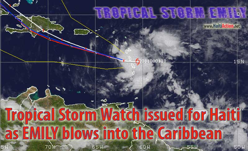
HaitiAction.net - Port au Prince, Haiti —A fast moving Tropical Storm is blowing over the Lesser Antilles islands of Dominica and Martinique. Tropical Storm EMILY is forecast by the National Hurricane Center (NHC) in Miami to slice across Haiti and the Dominican Republic (DR) by Wednesday afternoon. Wisely, the NHC is not overly-optimistic about EMILY's development into a stronger hurricane. This skepticism is the result of most computer models that has EMILY interacting with the land masses as it expects the storm to turn northward soon.
As conjectured here on HaitiAction.net, a couple days ago, it was suggested that in order for EMILY to gain strength it would have to slow it's forward speed and continue to take a westerly course directly into the Caribbean. EMILY has a WbN heading of 275º and a forward speed of 17mph. The strength of the tropical cyclone has an initial intensity of 40 mph. It was thought by the NHC that the inverted trough over Haiti would allow the storm to turn towards a more northerly heading soon. At this time the forecast model consensus has EMILY slicing directly over Port au Prince. The storm is expected to cause deadly landslides and flash floods in the mountainous regions.
It's more likely that the mid-level ridge and steering currents to the north will keep EMILY below 15.5N for the next 24 hours. If this happens EMILY will pass through the center of the open Caribbean about 200 miles south of Port au Prince. The forward progress is likely to slow — local winds are below 5mph — and the storm could gain intensity surprisingly fast over the warmer open waters of the East Caribbean. It is likely that EMILY will pass just to the south of the Eastern Caribbean NOAA Weather Buoy — Station 42059 — which could provide weather watchers a front row seat to the data provided by following that link.
EMILY is headed toward a large area of dry air, "…and in fact the latest GFDL model run even dissipates the cyclone in about two days…" according to the NHC.
HaitiAction.net will be tracking the progress of this storm. For the latest official updates, go to the Centre National de Météorologie (CNM) web page Many forecast and tracking resources can be found on the Tropical Cyclone page at HaitiAction.net
BOOKMARK Haiti Action.net Tropical Cyclone Page
For Hurricane Season resources and updates
Share this story with your networks
SEE ALSO
Contact: info@haitiaction.org
Haiti: Alarming resurgence of cholera Jun 9
La Gavage: Obama helps Republican militarists take control in Haiti May 13
The return of President Aristide to his home in Haiti Mar 20
Haiti: MSF Nears 100,000 Cholera Patients Treated Jan 18
Workshop for Haiti Media: Protocols on sexual gender-based violence in Haiti Apr 26
Grassroots groups present counter-perspective on Haiti's human rights record Mar 26
Mesaj Prezidan Aristide lè li rive an Ayiti 24 Mar
US Embassy in Haiti, respect the Will of the People of Haiti
Congresswoman Waters opposes plot to control Haiti Jan 18